![](/images/other/stat-length.png)
![Tour Mountainbike La Brigue - Espace VTT FFC Haute Roya - N° 11 - Rio Secco - Photo](https://media.geolcdn.com/t/1900/400/ext.pjpeg?maxdim=2&url=https%3A%2F%2Fstatic1.geolcdn.com%2Fsiteimages%2Fupload%2Ffiles%2F1524743154velo.jpg)
Espace VTT FFC Haute Roya - N° 11 - Rio Secco
tracegps
Benutzer
![Länge](/images/other/stat-length.png)
Länge
3,9 km
![Maximale Höhe](https://static1.geolcdn.com/siteimages/upload/files/1508320355ic_sort_altitude_max_24dp.png)
Maximale Höhe
959 m
![Positive Höhendifferenz](https://static1.geolcdn.com/siteimages/upload/files/1508320355ic_sort_den_pos_24dp.png)
Positive Höhendifferenz
222 m
![Km-Effort](/images/other/stat-length.png)
Km-Effort
6,8 km
![Min. Höhe](https://static1.geolcdn.com/siteimages/upload/files/1508320355ic_sort_altitude_min_24dp.png)
Min. Höhe
762 m
![Negative Höhendifferenz](https://static1.geolcdn.com/siteimages/upload/files/1508320355ic_sort_den_neg_24dp.png)
Negative Höhendifferenz
217 m
![Boucle](https://static1.geolcdn.com/siteimages/upload/files/16400158638029165_repeat_loop_refresh_sync_direction_icon.png)
Boucle
Ja
Erstellungsdatum :
2014-12-10 00:00:00.0
Letzte Änderung :
2014-12-10 00:00:00.0
![Mountainbike](https://static1.geolcdn.com/sitytour/trail-icons/202.png)
19m
Schwierigkeit : Einfach
![Scannen Sie diesen QR-Code, um die Tour in der SityTrail-Anwendung zu öffnen](https://capi.geolives.com/qq0zvz2zws4bq2lad0pu/sitytour/trails/101899/qr.png?size=200)
Kostenlosegpshiking-Anwendung
Über SityTrail
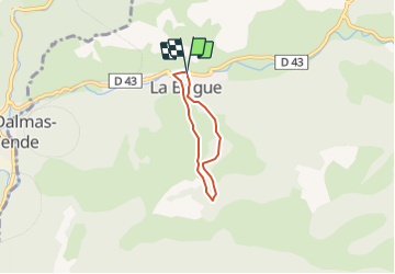
Tour Mountainbike von 3,9 km verfügbar auf Provence-Alpes-Côte d'Azur, Seealpen, La Brigue. Diese Tour wird von tracegps vorgeschlagen.
Beschreibung
Espace VTT - FFC Haute Roya Circuit labellisé par la Fédération Française de Cyclisme. Idéal pour s'échauffer ou faire une balade en famille. Une boucle autour d ela Brigue ombragée et peu technique.
Ort
Land:
France
Region :
Provence-Alpes-Côte d'Azur
Abteilung/Provinz :
Seealpen
Kommune :
La Brigue
Standort:
Unknown
Gehen Sie:(Dec)
Gehen Sie:(UTM)
389165 ; 4879848 (32T) N.
Kommentare
Touren in der Umgebung
![Tour Zu Fuß La Brigue - Cime de Marta - Photo](https://media.geolcdn.com/t/375/260/c0cfb9a6-76b9-4942-9ef0-2c0cdd15d81a.jpeg&format=jpg&maxdim=2)
![Zu Fuß Zu Fuß](https://static1.geolcdn.com/sitytour/trail-icons/100.png)
Cime de Marta
Zu Fuß
Medium
La Brigue,
Provence-Alpes-Côte d'Azur,
Seealpen,
France
![](/images/other/stat-length.png)
13,9 km | 27 km-effort
6h 4min
![](https://static1.geolcdn.com/siteimages/upload/files/16400158638029165_repeat_loop_refresh_sync_direction_icon.png)
Ja
![Tour Zu Fuß Fontan - Tour de Gauron - Photo](https://media.geolcdn.com/t/375/260/db60aa02-ad12-4630-8139-90b896097fd9.jpeg&format=jpg&maxdim=2)
![Zu Fuß Zu Fuß](https://static1.geolcdn.com/sitytour/trail-icons/100.png)
Tour de Gauron
Zu Fuß
Medium
Fontan,
Provence-Alpes-Côte d'Azur,
Seealpen,
France
![](/images/other/stat-length.png)
11,1 km | 23 km-effort
5h 13min
![](https://static1.geolcdn.com/siteimages/upload/files/16400158638029165_repeat_loop_refresh_sync_direction_icon.png)
Ja
![Tour Wandern Fontan - Bergue Inférieur - Tour de Corvo - 2016 06 30 - Photo](https://media.geolcdn.com/t/375/260/ext.jpg?maxdim=2&url=https%3A%2F%2Fservices.sitytrail.com%2FGeolivesWS%2FDownloadMedia.ashx%3FTrailID%3D597852%26Media%3Dfix__20160630135626.jpg)
![Wandern Wandern](https://static1.geolcdn.com/sitytour/trail-icons/101.png)
Bergue Inférieur - Tour de Corvo - 2016 06 30
Wandern
Medium
Fontan,
Provence-Alpes-Côte d'Azur,
Seealpen,
France
![](/images/other/stat-length.png)
10,1 km | 18,4 km-effort
3h 40min
![](https://static1.geolcdn.com/siteimages/upload/files/16400158638029165_repeat_loop_refresh_sync_direction_icon.png)
Ja
![Tour Wandern Tende - tende boucle - Photo](https://media.geolcdn.com/t/375/260/62c5f523-2f83-4b76-96b8-df3883db8512.jpg&format=jpg&maxdim=2)
![Wandern Wandern](https://static1.geolcdn.com/sitytour/trail-icons/101.png)
tende boucle
Wandern
Einfach
Tende,
Provence-Alpes-Côte d'Azur,
Seealpen,
France
![](/images/other/stat-length.png)
10,2 km | 12,9 km-effort
1h 16min
![](https://static1.geolcdn.com/siteimages/upload/files/16400158638029165_repeat_loop_refresh_sync_direction_icon.png)
Nein
![Tour Wandern La Brigue - la Brigue boucle par notre dame des fontaines - Photo](https://media.geolcdn.com/t/375/260/84181023-435b-4f93-86c0-ab38cd111cfe.jpg&format=jpg&maxdim=2)
![Wandern Wandern](https://static1.geolcdn.com/sitytour/trail-icons/101.png)
la Brigue boucle par notre dame des fontaines
Wandern
Medium
La Brigue,
Provence-Alpes-Côte d'Azur,
Seealpen,
France
![](/images/other/stat-length.png)
18,1 km | 25 km-effort
4h 52min
![](https://static1.geolcdn.com/siteimages/upload/files/16400158638029165_repeat_loop_refresh_sync_direction_icon.png)
Ja
![Tour Wandern Tende - castel tournou - Photo](https://media.geolcdn.com/t/375/260/39bc4b5c-37a4-4af2-93f2-0eaa9196e8d4.jpg&format=jpg&maxdim=2)
![Wandern Wandern](https://static1.geolcdn.com/sitytour/trail-icons/101.png)
castel tournou
Wandern
Medium
Tende,
Provence-Alpes-Côte d'Azur,
Seealpen,
France
![](/images/other/stat-length.png)
7 km | 13,5 km-effort
4h 20min
![](https://static1.geolcdn.com/siteimages/upload/files/16400158638029165_repeat_loop_refresh_sync_direction_icon.png)
Ja
![Tour Wandern Fontan - Berghe - Cime Corvo - Photo](https://media.geolcdn.com/t/375/260/e2ea6854-9dd0-41dd-bbdb-2d93c5cf055f.jpg&format=jpg&maxdim=2)
![Wandern Wandern](https://static1.geolcdn.com/sitytour/trail-icons/101.png)
Berghe - Cime Corvo
Wandern
Einfach
Fontan,
Provence-Alpes-Côte d'Azur,
Seealpen,
France
![](/images/other/stat-length.png)
10,7 km | 19,3 km-effort
3h 45min
![](https://static1.geolcdn.com/siteimages/upload/files/16400158638029165_repeat_loop_refresh_sync_direction_icon.png)
Ja
![Tour Wandern La Brigue - La Brigue - 2016 06 24 - Photo](https://media.geolcdn.com/t/375/260/ext.jpg?maxdim=2&url=https%3A%2F%2Fservices.sitytrail.com%2FGeolivesWS%2FDownloadMedia.ashx%3FTrailID%3D597957%26Media%3Dfix__20160624173418.jpg)
![Wandern Wandern](https://static1.geolcdn.com/sitytour/trail-icons/101.png)
La Brigue - 2016 06 24
Wandern
Sehr leicht
La Brigue,
Provence-Alpes-Côte d'Azur,
Seealpen,
France
![](/images/other/stat-length.png)
2,8 km | 3,3 km-effort
1h 10min
![](https://static1.geolcdn.com/siteimages/upload/files/16400158638029165_repeat_loop_refresh_sync_direction_icon.png)
Ja
![Tour Wandern Fontan - Berghe, Granit, Pas de la Tranché, col de Tâte, Granges d'Amatte - Photo](https://media.geolcdn.com/t/375/260/ext.jpg?maxdim=2&url=https%3A%2F%2Fservices.sitytrail.com%2FGeolivesWS%2FDownloadMedia.ashx%3FTrailID%3D411439%26Media%3Dfix__20150423172427.jpg)
![Wandern Wandern](https://static1.geolcdn.com/sitytour/trail-icons/101.png)
Berghe, Granit, Pas de la Tranché, col de Tâte, Granges d'Amatte
Wandern
Medium
Fontan,
Provence-Alpes-Côte d'Azur,
Seealpen,
France
![](/images/other/stat-length.png)
17,6 km | 31 km-effort
6h 45min
![](https://static1.geolcdn.com/siteimages/upload/files/16400158638029165_repeat_loop_refresh_sync_direction_icon.png)
Ja